

The closing is two weeks away. The title company has emailed asking for the APN, but the only property detail available is a street address copied from an old tax bill. The mailbox confirms the address, yet the county's title and tax systems don't use the mailbox as their primary key. They use the parcel identifier.
That identifier may be called an APN, parcel number, PIN, folio, or tax parcel ID, depending on the jurisdiction. It connects the property to tax records, deeds, title work, assessments, easements, and other land records. If you're researching an inherited lot, preparing a tax appeal, reviewing an escrow statement, or checking a utility easement, finding the correct parcel number is often the first step. The same lookup can also clarify ownership boundaries before you decide whether to sell inherited land.
The Address Without a Parcel Number Problem
A street address is designed for people, mail carriers, emergency services, and delivery companies. A parcel number is designed for the land-record system. Those systems overlap, but they aren't identical.
The address may have changed, been abbreviated differently, or been entered with an apartment or unit designation that the county database doesn't recognize. A rural property may use a mailing city that doesn't match the county governing the parcel. A lot may have no assigned street address at all. The address can be perfectly understandable to a person and still fail in the assessor's search box.
Practical rule: Treat the address as a starting clue, not as the legal identity of the land.
The parcel number matters because government offices and private professionals use it to connect records to a specific land unit. An assessor may use it for valuation and taxation. A recorder may associate it with a deed or easement. A title company may request it to locate the property in its search system. A landowner may need it to identify the correct parcel before filing an appeal, reviewing delinquent taxes, or discussing a sale.
The identifier also helps separate neighboring properties with similar addresses. A house, a detached lot, and a shared driveway may sit under related mailing information while appearing as different parcels in the county map. Conversely, one address may be associated with more than one parcel after a subdivision, condominium arrangement, or other legal change.
Why the lookup can feel harder than it should
The practical solution is usually an official public parcel search that accepts an address or an existing parcel identifier. Estonia's government cadastral portal illustrates the address-to-parcel relationship clearly. It allows searches by full address, short address, identifier, or user location, and it requires a complete address containing the settlement unit, municipality, and county. Its example cadastral identifier is 40302:001:0238. See the Estonian cadastral register query guidance for the structure of that workflow.
The specific labels and search rules vary, but the underlying task is consistent: match an everyday address to the legally defined land unit. The rest of the process is about choosing the right county, using the right portal, and recognizing when the text search is the problem rather than the parcel.
Running the County Assessor Search Step by Step
Start with the county, not with a third-party property website. The correct county is the jurisdiction most likely to maintain the authoritative parcel record, and a city name in the mailing address can mislead you when the property is unincorporated or near a boundary.
Find the official search page
Use a search phrase such as the county name plus assessor parcel search, property records, or GIS parcel viewer. Prefer the county's official government website. County portals may run on systems such as Beacon, Tyler iasWorld, Devnet, or Aumentum, but the vendor matters less than the government source behind the page.
Official county systems commonly expose fields labeled:
- Property Address
- Street Number
- Street Name
- Parcel ID
- Parcel Number
- Tax Parcel Number
- Owner Name
Pima County's official parcel search states that searching by street address is its easiest and most accurate address method. Its parcel code example shows why format awareness matters: the system accepts an 8-digit numeric code plus a final alphanumeric character, or an 11-character dashed format, such as 11711001B or 117-11-001B. Review the Pima County GIS parcel search instructions before assuming your county uses the same pattern.
Enter the address in the county's language
Type the house number and street name into the fields the portal provides. If the system separates street direction, name, and suffix, enter each piece separately rather than pasting the complete mailing line into one box.
Try the address without an apartment or unit number first. A unit may belong in a separate field, may be indexed under a condominium record, or may not be accepted by the address search at all. If the portal offers an owner-name search, use it as a fallback when the address produces no result and you know the current or former owner.

Read the parcel card carefully
A successful result usually displays the parcel number near the top of the record, beside the property address or tax account information. It may appear as a string with county-specific separators, often using dashes. Copy it exactly, including leading zeros, letters, prefixes, and punctuation.
Check the owner name, situs address, legal description summary, and map reference before you save the number. San Diego County's official property-record guidance is one example of a government workflow that directs users to search property records by address or parcel information through the assessor's system. The San Diego County property records page is useful as a reference for the general county-records approach.
If the result shows several similar addresses, don't select the first one automatically. Compare the street direction, unit, owner, parcel map, and situs details. The right APN is the one tied to the land you're researching, not merely the closest text match.
Using the GIS Parcel Viewer When the Search Falls Short
The GIS viewer is the best fallback when the assessor's address form returns no hits, rejects a unit number, or contains an obvious spelling mismatch. A text search asks the database to recognize your wording. A map search lets you identify the land visually.
Open the parcel map
Search for the county's official GIS parcel map, ParcelViewer, or MapOffice page. Many county viewers use ArcGIS or a similar mapping platform. Look for a layer named Parcels, Tax Parcels, Cadastral Parcels, or Property Boundaries.
If the viewer opens at a statewide or countywide extent, search the address in the map's general search box first. If that fails, use the road network, nearby intersections, subdivision name, aerial imagery, or a known landmark to move to the property area. Rural parcels often resolve more easily from a map than from a standardized street-address field.
Click the parcel polygon
Turn on parcel boundaries and, where available, parcel labels. Zoom in until individual polygons are visible, then click the parcel that contains the house, driveway, or vacant lot. The pop-up or result panel may display the APN, parcel ID, owner of record, acreage, situs address, and legal description summary.
Don't assume the parcel containing the structure is the only relevant parcel. A residence may sit on one parcel while a neighboring strip, access tract, or separate lot is held under another identifier. Review the surrounding polygons before copying the result.
Map boundaries help you identify the record. They don't replace a survey or a legal description when the exact boundary is disputed.
Use partial searches and labels
Some viewers provide a parcel-code search field that accepts a partial address, subdivision name, or abbreviated street spelling. This is particularly useful when you're uncertain whether the county records the road as “Road,” “Rd,” “Highway,” or another local variant.
A GIS viewer can also expose records that the assessor's form doesn't return because the map is querying the parcel layer directly. That doesn't make every map result conclusive. County GIS data can have different update timing from tax, deed, or recorder systems, so use the parcel number as a bridge to the underlying official record rather than treating every displayed field as final.

When a property sits near a road, municipal boundary, or county line, compare the map position with the situs address and parcel outline. The mailing city can describe the community people recognize while the parcel itself remains in a surrounding county. That distinction is common enough that it should be checked, not guessed.
Decoding APN, PIN, Folio, and Other Identifier Formats
The first identifier you find may not be called an APN. Counties use different labels for similar administrative keys, and some systems distinguish between identifiers that look interchangeable on the screen.
| Identifier Term | Common State or Region | Format Example | Pitfall to Watch |
|---|---|---|---|
| APN or Assessor Parcel Number | Common in California and other U.S. jurisdictions | 40302:001:0238 |
Don't assume another county uses the same grouping or punctuation |
| Parcel Number or Tax Parcel ID | County assessor and tax systems nationwide | County-specific string | The tax system may display a formatted version that another portal requires without separators |
| PIN or Property Identification Number | Used in some Illinois and Florida systems | Jurisdiction-specific string | A PIN may not be interchangeable with another local account number |
| Folio | Miami-Dade and other Florida records contexts | Miami-Dade describes a 13-digit folio identifier | Preserve every digit and confirm whether the receiving system calls for folio or parcel ID |
| Block and lot | Northeastern municipal systems | Block and lot components | Enter each component in the field the city or county provides |
| Cadastral identifier | Cadastral systems outside the United States | 40302:001:0238 |
Address matching may require the settlement, municipality, and county |
These labels describe local practice, not a national naming standard. Miami-Dade's parcel search, for example, describes the folio as a 13-digit parcel identifier in its official search interface. Other jurisdictions may call the key a serial number, tax account number, or parcel code.
Preserve the county's exact format
Formatting errors cause many silent failures. A portal may require dashes, reject dashes, expect a county prefix, or require leading zeros that a spreadsheet has stripped. Livingston County's instructions say its parcel ID should be searched without the county code 47 and with dashes. Napa County documentation, by contrast, accepts compact and dashed formats, while another county GIS system warns that a parcel number isn't the same as a PIN. Those differences are documented in the Gaston County GIS property search, which demonstrates why you should read the local instructions instead of relying on the label alone.
Keep two versions in your notes when appropriate:
- The identifier exactly as printed by the county.
- A plain-text version with separators removed, only if the receiving system requests it.
Never delete leading zeros. Don't paste an APN into a title portal until you've checked whether that portal wants the formatted parcel number, a tax account, a book-map-parcel sequence, or a different local identifier altogether.
Why a Normal Address Returns Nothing and How to Fix It
“Type the address into the assessor's website” is a useful starting instruction, but it isn't a complete method. County portals can limit results to the current map extent, require exact local formatting, reject punctuation, or treat unit text differently from the mailing service. Official systems continue to vary in their search design, which is why troubleshooting matters as much as the initial lookup.
Address normalization is the first suspect
Try the street number and street name without the unit, apartment, punctuation, or directional suffix. Test common alternatives such as Street and St, North and N, or the local road designation. If the portal has separate fields, split the components rather than entering the entire address in the street-name box.
For a condominium or multi-unit property, search the base street address first, then inspect the returned units or owner records. A unit number may be indexed in a separate field, under a building record, or not at all.
Check the jurisdiction, not just the mailing city
A property can use a recognizable city name for mailing while falling in an unincorporated area governed by the county. An “island” of county land inside or beside a city can create the same confusion. If the city assessor returns nothing, search the surrounding county's assessor and GIS portals.
County boundaries create a related problem. A road may run along a jurisdictional line, or an address database may associate the same road name with more than one county. Confirm the parcel location on a map before deciding that no record exists.
Use the map when text fails
If alternate address formats don't work, open the parcel viewer and click the polygon. Search by subdivision name, nearby road, or partial street name when those options exist. This approach is often faster than repeatedly guessing which abbreviation the database expects.
Recently split, merged, or otherwise changed parcels may also appear differently across assessor, GIS, tax, and deed systems. If the map shows land but the record is missing or stale, save the map location and contact the assessor's recording or property-records line. Ask which identifier is active and whether a prior parcel number was retired or replaced.
Do not treat zero search results as proof that the parcel doesn't exist. It may only prove that the portal didn't understand the address you entered.
What to Do With the Parcel Number Once You Have It
Finding the parcel number is a milestone, not the end of the research. Save the identifier with the exact county name, situs address, owner name shown by the portal, and the date you retrieved it. That context helps you distinguish an old parcel record from a neighboring parcel or a later split.
Put the APN to work
Use the number to pull the complete assessor record, including the tax account and property characteristics available through that jurisdiction. Then search the county recorder, register of deeds, or official recorded-document system for deeds, easements, releases, and other instruments. Some recorder systems index by parcel number, while others require the grantor, grantee, document number, or legal description.
Before a sale, review the records that can affect closing:
- Taxes: Check the current tax status and any delinquent balance shown by the appropriate tax office.
- Liens and assessments: Look for recorded liens, special assessments, or notices that may require title-company review.
- Legal description: Compare the deed's legal description with the parcel map and the physical property.
- Adjacent parcels: Identify neighboring owners when access, boundary work, or a land campaign requires more than the subject parcel.
The APN can also make appraisal research cleaner because it gives you a consistent key for locating comparable properties in the same county system. For vacant land, it helps separate a buildable lot from a nearby tract with a similar mailing address.
Know what the number can't answer
An APN doesn't prove current vesting by itself. The assessor may display an owner name for tax administration, but the recorder's records and title work determine how ownership is legally documented. The parcel number also doesn't establish acreage on its own. Confirm acreage against the legal description, survey, and authoritative parcel record.
For owners evaluating a sale, a clear parcel number reduces confusion during the initial review and title process. The broader transaction path, including due diligence, title coordination, and closing, is described in the land-buying process.
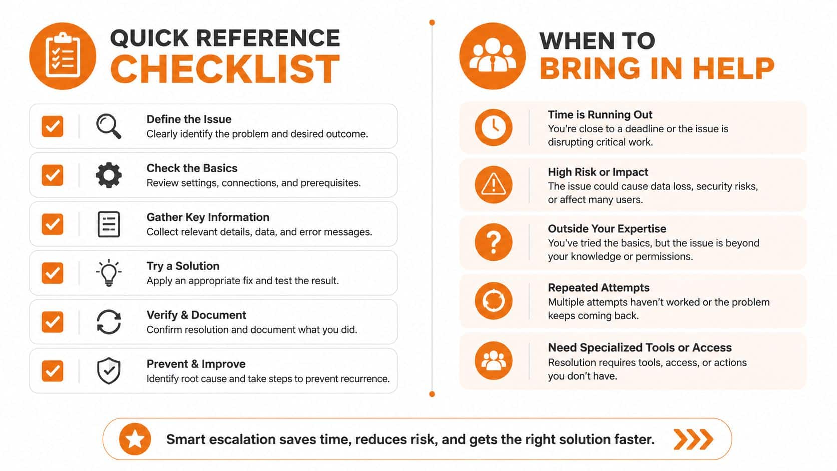
Quick Reference Checklist and When to Bring in Help
Run these checks in order. Each one should take only a short time, and each eliminates a common source of error.
- Confirm the county: Use the physical parcel location, not only the mailing city or ZIP code.
- Open the official assessor page: Search for the county's property-records or parcel-search portal.
- Try the base address: Enter the house number and street name without the unit or punctuation if the first search fails.
- Test local variants: Swap directional and street-suffix abbreviations to match the portal's conventions.
- Search by owner name: Use this fallback when you know the owner but the address field rejects your entry.
- Open the GIS viewer: Search the map by address, subdivision, nearby road, or visible landmarks.
- Click the parcel polygon: Read the pop-up for the APN, parcel ID, owner field, and other available record details.
- Copy the identifier exactly: Preserve dashes, letters, prefixes, and leading zeros.
- Verify the location: Compare the parcel shape with aerial imagery, the driveway, structures, and access route.
- Cross-check the record: Match the parcel number to the assessor record or recorded document before using it for title work.
If the parcel still won't resolve, bring in help based on the problem. A title abstractor can trace recorded instruments and ownership history. A licensed surveyor is the right professional for disputed lines, uncertain acreage, or questions about where the parcel lies. The county assessor or recorder's office can explain local indexing and whether a parcel was split, merged, renumbered, or moved into a different record series.
Properties near city and county boundaries deserve extra care. So do inherited parcels with missing deeds, delinquent obligations, unclear access, or a title history that requires document-by-document review. If you're comparing professional options for a land sale, review land-buying companies carefully and confirm who handles title, escrow, and closing.
If you've found the parcel number but don't want to manage the next steps alone, Swift Land Buyers reviews vacant land and residential lots, coordinates due diligence through title companies, and can make an as-is cash offer without requiring cleanup or an MLS listing. Visit the site with the address, parcel number, and any tax or title documents you have, so the property can be reviewed from the correct land record.